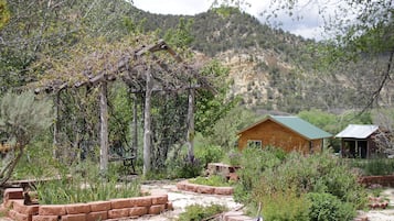
![Take Hwy 89 through the Dixie National Forest. Hot in summer. Beautiful area to explore.
Dixie National Forest is a United States National Forest in Utah with headquarters in Cedar City. It occupies almost two million acres (8,000 km²) and stretches for about 170 miles (270 km) across southern Utah. The largest national forest in Utah, it straddles the divide between the Great Basin and the Colorado River. In descending order of forestland area it is located in parts of Garfield, Washington, Iron, Kane, Wayne, and Piute counties. The majority (over 55%) of forest acreage lies in Garfield County. There are local ranger district offices in Cedar City, Escalante, Panguitch, St. George, and Teasdale.[3]
Elevations vary from 2,800 feet (850 m) above sea level near St. George, Utah to 11,322 feet (3,451 m) at Blue Bell Knoll on Boulder Mountain. The southern rim of the Great Basin, near the Colorado River, provides spectacular scenery. Colorado River canyons are made up of multi-colored cliffs and steep-walled gorges.
The Forest is divided into four geographic areas. High altitude forests in gently rolling hills characterize the Markagunt, Paunsaugunt, and Aquarius Plateaus. Boulder Mountain, one of the largest high-elevation plateaus in the United States, is dotted with hundreds of small lakes 10,000 to 11,000 feet (3,000 to 3,400 m) above sea level. The forest includes the Pine Valley Mountains north of St. George
The Forest has many climatic extremes. Precipitation ranges from 10 inches (250 mm) in the lower elevations to more than 40 inches (1,000 mm) per year near Brian Head Peak 11,307 feet (3,446 m). At the higher elevations, most of the annual precipitation falls as snow. Thunderstorms are common during July and August and produce heavy rains. In some areas, August is the wettest month of the year.
Temperature extremes can be impressive, with summer temperatures exceeding 100 degrees Fahrenheit (38 degrees Celsius) near St. George and winter lows exceeding -30 degrees Fahrenheit (-34 degrees Celsius) on the plateau tops.
The vegetation of the Forest grades from sparse, desert-type plants at the lower elevations to stand of low-growing pinyon pine and juniper dominating the mid-elevations. At the higher elevations, aspen and conifers such as pine, spruce, and fir predominate.
The Dixie Forest Reserve was established on September 25, 1905 by the General Land Office. The name was derived from the local description of the warm southern part of Utah as "Dixie".[4] In 1906 the U.S. Forest Service assumed responsibility for the lands, and on March 4, 1907 it became a National Forest. The western part of Sevier National Forest was added on July 1, 1922, and all of Powell National Forest on October 1, 1944.[5] #RoadTrip](https://images.trvl-media.com/place/553248623139890761/0fda4c56-7838-41e8-8b93-58002efa6942.jpg?impolicy=fcrop&w=1200&h=500&q=medium)
Photo by Eric & Kristy's Adventures
Search Alton hotels

Change your mind
Book hotels with free cancellation


Be picky
Search almost a million properties worldwide
Go beyond your typical stay in Alton
Cabin
Family friendly
Check prices for these dates
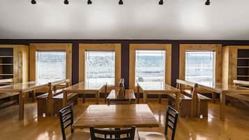
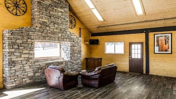
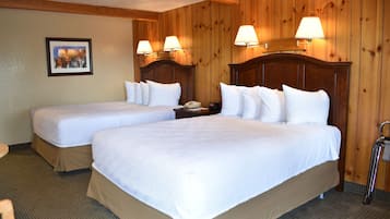
Top hotels and accommodation in Alton
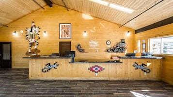

Quality Inn Bryce Canyon
Quality Inn Bryce Canyon
8.0 out of 10, Very good, (1027)
"This place was so good "

Tae Kyoung
The price is AU$125
includes taxes & fees
8 Nov - 9 Nov


Bryce Canyon Pines
Bryce Canyon Pines
8.0 out of 10, Very good, (951)
"Great location, nice hotel"
Barry
The price is AU$112
includes taxes & fees
27 Oct - 28 Oct


Rodeway Inn Bryce Canyon
Rodeway Inn Bryce Canyon
8.0 out of 10, Very good, (1005)
"Property was clean, staff were friendly and helpful."
Dawn
The price is AU$74
includes taxes & fees
23 Nov - 24 Nov


Mountain Ridge Cabins and Lodging
Mountain Ridge Cabins and Lodging
9.2 out of 10, Wonderful, (985)
"Loved the easy check in and how clean the cabin is."
Jane


89 & Nine Motel
89 & Nine Motel
8.6 out of 10, Excellent, (126)
"An older motel convenient to Zion No front desk staff but remote check in worked great. I’d stay again."
Joe


Best Western East Zion Thunderbird Lodge
Best Western East Zion Thunderbird Lodge
9.0 out of 10, Wonderful, (1007)
"Restaurant was nice and had very good food "
Lisa
The price is AU$176
includes taxes & fees
2 Nov - 3 Nov


Lowest nightly price found within the past 24 hours based on a 1 night stay for 2 adults. Prices and availability subject to change. Additional terms may apply.

Save an average of 15% on thousands of hotels when you're signed in
Stay near popular Alton attractions
Learn more about Alton
Nestled near the stunning Dixie National Forest, this tiny town offers hikers access to Red Hollow Canyon Trailhead and Mammoth Cave. Explore the natural wonders of Bryce Natural Bridge and Fairview Point, where southern Utah's remarkable landscapes unfold in every direction.
![Take Hwy 89 through the Dixie National Forest. Hot in summer. Beautiful area to explore.
Dixie National Forest is a United States National Forest in Utah with headquarters in Cedar City. It occupies almost two million acres (8,000 km²) and stretches for about 170 miles (270 km) across southern Utah. The largest national forest in Utah, it straddles the divide between the Great Basin and the Colorado River. In descending order of forestland area it is located in parts of Garfield, Washington, Iron, Kane, Wayne, and Piute counties. The majority (over 55%) of forest acreage lies in Garfield County. There are local ranger district offices in Cedar City, Escalante, Panguitch, St. George, and Teasdale.[3]
Elevations vary from 2,800 feet (850 m) above sea level near St. George, Utah to 11,322 feet (3,451 m) at Blue Bell Knoll on Boulder Mountain. The southern rim of the Great Basin, near the Colorado River, provides spectacular scenery. Colorado River canyons are made up of multi-colored cliffs and steep-walled gorges.
The Forest is divided into four geographic areas. High altitude forests in gently rolling hills characterize the Markagunt, Paunsaugunt, and Aquarius Plateaus. Boulder Mountain, one of the largest high-elevation plateaus in the United States, is dotted with hundreds of small lakes 10,000 to 11,000 feet (3,000 to 3,400 m) above sea level. The forest includes the Pine Valley Mountains north of St. George
The Forest has many climatic extremes. Precipitation ranges from 10 inches (250 mm) in the lower elevations to more than 40 inches (1,000 mm) per year near Brian Head Peak 11,307 feet (3,446 m). At the higher elevations, most of the annual precipitation falls as snow. Thunderstorms are common during July and August and produce heavy rains. In some areas, August is the wettest month of the year.
Temperature extremes can be impressive, with summer temperatures exceeding 100 degrees Fahrenheit (38 degrees Celsius) near St. George and winter lows exceeding -30 degrees Fahrenheit (-34 degrees Celsius) on the plateau tops.
The vegetation of the Forest grades from sparse, desert-type plants at the lower elevations to stand of low-growing pinyon pine and juniper dominating the mid-elevations. At the higher elevations, aspen and conifers such as pine, spruce, and fir predominate.
The Dixie Forest Reserve was established on September 25, 1905 by the General Land Office. The name was derived from the local description of the warm southern part of Utah as "Dixie".[4] In 1906 the U.S. Forest Service assumed responsibility for the lands, and on March 4, 1907 it became a National Forest. The western part of Sevier National Forest was added on July 1, 1922, and all of Powell National Forest on October 1, 1944.[5] #RoadTrip](https://images.trvl-media.com/place/553248623139890761/0fda4c56-7838-41e8-8b93-58002efa6942.jpg?impolicy=fcrop&w=900&h=696&p=1&q=high)
Photo by Eric & Kristy's Adventures
Open Photo by Eric & Kristy's Adventures
Top Alton Hotel Reviews

Mountain Ridge Cabins and Lodging
10/10 Excellent


More cheap accommodation in Alton

Bryce Canyon Pines
2476 W HWY 12, Bryce Canyon, UT
The price is AU$112 per night from 27 Oct to 28 Oct
AU$112
27 Oct - 28 Oct
includes taxes & fees
8/10 Very Good! (936 reviews)


Frequently asked questions
Explore a world of travel with Expedia
- Hotels near Alton Amphitheater
- Hotels near Angels Landing
- Brian Head Hotels
- Hotels near Brian Head Ski Resort
- Hotels near Bryce Canyon
- B&B in Bryce Canyon
- Country House in Bryce Canyon
- Boutique Hotels in Bryce Canyon
- Business Hotels in Bryce Canyon
- Cheap Hotels in Bryce Canyon
- Family Hotels in Bryce Canyon
- Golf Hotels in Bryce Canyon
- Hotels with Parking in Bryce Canyon
- Luxury Hotels in Bryce Canyon
- Spa Hotels in Bryce Canyon
- Winery Hotels in Bryce Canyon
- Bryce Canyon Hotels
- Inns in Bryce Canyon
- Lodges in Bryce Canyon
- Motels in Bryce Canyon
- Hotels near Bryce Canyon National Park
- Hotels near Bryce Canyon National Park Visitor Center
- Safari Tentalow in Bryce Canyon
- Hotels near Bryce Point
- Hotels near Bryce Wildlife Adventure
- Cannonville Hotels
- Motels in Cannonville
- Hotels near Dixie National Forest
- Cabin Rentals in Duck Creek Village
- Farmstay in Duck Creek Village
- Duck Creek Village Hotels
- Cabin Rentals in Glendale
- Cheap Hotels in Glendale
- Glendale Hotels
- Motels in Glendale
- Villas in Glendale
- Farmstay in Hatch
- Hatch Hotels
- Kanab Hotels
- Long Valley Junction Hotels
- Hotels near Mammoth Cave
- Hotels near Mossy Cave Trail
- Apartments in Mount Carmel
- Mount Carmel Hotels
- Cheap Hotels in Mount Carmel Junction
- Mount Carmel Junction Hotels
- Safari Tentalow in Mount Carmel
- Hotels near Old Bryce Town
- Cheap Hotels in Orderville
- Hotels with Parking in Orderville
- Orderville Hotels
- Motels in Orderville
- Panguitch Hotels
- Panguitch Lake Resort Hotels
- Resort in Panguitch Lake Resort
- Hotels near Red Canyon
- Caravan Parks in Southwestern Utah - Bryce Canyon
- Adults Only Hotels in Southwestern Utah - Bryce Canyon
- Cheap Hotels in Southwestern Utah - Bryce Canyon
- Luxury Hotels in Southwestern Utah - Bryce Canyon
- Southwestern Utah - Bryce Canyon Hotels
- Lodges in Southwestern Utah - Bryce Canyon
- Resort in Southwestern Utah - Bryce Canyon
- Hotels near Sunset Point
- B&B in Tropic
- Cheap Hotels in Tropic
- Tropic Hotels
- Hotels near Zion National Park East Entrance
- Flights to Bryce Canyon
- Flights to Glendale
- Flights from Bryce Canyon
- Flights from Bryce Canyon
- Flights from Brisbane (BNE) to Bryce Canyon (BCE)
- Flights from Chicago (CHI) to Bryce Canyon (BCE)
- Flights from Houston (IAH) to Bryce Canyon (BCE)
- Flights from Las Vegas (LAS) to Bryce Canyon (BCE)
- Flights from Ontario (ONT) to Bryce Canyon (BCE)
- Bryce Canyon National Park
- Bryce Canyon National Park Visitor Center
- Bryce Canyon Holidays
- Bryce Point
- Visit Cannonville
- Cascade Falls
- Visit Duck Creek Village
- Hatch Holidays
- Visit Long Valley Junction
- Mossy Cave Trail
- Mount Carmel Holidays
- Panguitch Lake
- Piracy Point
- Queens Garden Trail
- Rainbow Point
- Red Canyon Visitor Center
- Rim Road Scenic Drive

